

Email me your favorite practice tracks and I will post them here. web master@otmx.com
| Washoe Valley Jumbo Grade -
From Reno take 395 south. Turn South on East Lake in Washoe Valley (By Little Washoe Lake). Go South past the 7-11 store to Jumbo Grade road. Turn left. Follow road until it turns to dirt. Go past the big dirt pit on the right and look around. Lots of space to ride with 4 practice tracks on other side of creek. Jumbo Grade road does go over the hills to Virginia City. |
| Moonrocks MX track. Take Pyramid hwy 20 miles north of Sparks to Winnemucca Ranch Road. Turn North. Drive about 8 miles. Moonrocks are visible on the left. |
|
The land is managed and marked "off road friendly" by the BLM who ask that you only ride on the trails. Some of the trails are also managed by the Hungry Valley Indian Community. Riders should also become active in the Hungry Valley Indian Communities fight to keep this land accessible to all of us and out of the hands of a Chicago, IL. based company that is trying to turn it all into a kitty litter mine. The main trails are easily accessible by taking Pyramid Way out of Reno North of McCarran. Keep traveling out on Pyramid until you hit Spanish Springs. You'll see a 7-11 on the left. Turn left at that light and follow the road all the way up the Mountain and past the high school. Once over the mountain there is plenty of parking on the left (keep going on this road and you'll be in the Hungry Valley Indian Reservation). I like to turn right just past the High School (on the left) and park at the Spanish Springs Public Airport (Dirt road and runway, signs mark the way). It has a dirt parking lot with a banked hill you can back your truck to and you won't need a ramp to unload your bikes. There's a hidden canyon behind the airport that makes for a great ride. Just head behind the airport towards the gravel pit you'll see it. The trail starts along the fence that closes the gravel pit off. It looks like it goes nowhere, but if you venture down the canyon you'll find an excellent trail that goes back for miles. The beginning trail is nice soft dirt, but the quads keep knocking down the banked turns. 4X4's can't fit between the rocks so its not hard packed. About a 1/4 of the way back there are 2 very large rocks just wide enough to squeeze a bike between, but fortunately quads can't squeeze past so its all MX from there on out. The trail winds back through the canyon and up to the top of the mountain for miles. Towards the end there are two great challenging trails. One option takes you straight up a very long mountain climb The other takes you down a banked turn soft dirt canyon. However be warned, the easy route (down) ends with large boulders at the bottom for about 20 yards that can be rolled over on a bike but may not be found very beginner friendly. After that you can shoot across the open valley to the mountain across the way and follow the trails around. It will make a big loop and eventually bring you back to the airport. Make sure your tank is topped off before you leave. Its a full tank ride running the full circuit. Also: There is a small track on the North West corner of McCarran and Pyramid that is marked by the BLM as stay on the trails rideable. Take Pyramid past McCarran about 1 mile. On the left you'll see a dirt area that can be parked on. Ride up the hill following Pyramid back towards McCarran. The track begins at the top of that hill and has several semi-soft bermed turns and a couple really good jumps. Most of the track is hard packed from 4X4's trying to ride on it, but the few turns are still semi soft from not being overly attractive or accessible to them. The track is small, but it is a track. Its close and its free. I've spent several hours out there with a pick and shovel removing large rocks and softening up the turns. The track can be seen from Pyramid on the left (heading towards Pyramid Lake if your looking for it). At the top of the hill you'll also find a pile of large rocks. I like to use these to block the road off when I'm ridding the track by pushing them into the road. If you don't, people in cars will try to drive up there and park right at the top of the best jump on the track so they can drink beer (and break their bottle on the track).
|
| Prison Hill - One mile east of the Champion Motor Speedway and east of the southern prison. Take 395 to Snyder (South end of Carson near El Charro Mexican restaurant). East on Snyder until it ends about two miles. Turn south on dirt road. Drive one half mile. Track is on the left. It is mostly a sand track. Pretty whooped. If you are having arm pump problems, this is the place to work it out. Someone has recently built four decent jumps with a loader. Be careful because the jumps have big holes between the doubles. If you come up short, you'll get hurt. Excellent practice for Fernley. Monster sand berms. | |
| Johnson Lane - Take Johnson Lane east from 395 until it turns to dirt. Continue about one mile. MX riding is to the North. It is mostly hardpack and sand. Some rocks. | |
Nevada Motocross Park:Track is located off of Hwy 395. Turn left if coming from the north, turn right coming from the south. Follow Pinenut Road for approximately 3 miles. Track is located on the left across from the Douglas County Fairgrounds. |
|
| Gardnerville Ranchos gravel pits. Take 395 South to 88. South on 88 about 6 miles. Turn left on Kimmerling. Drive 2 miles and turn right on Tillman. Tillman turns into a dirt road in about a mile. Look for the big excavated hill to the Southeast. Park near the bottom and find your way around the pit to the top. The Forest Service has allowed some locals to prep a practice track up there. Stay out of the excavation area. This track has supercross size air. Mostly hardpack. Some rocks. | |
| Smith Valley | |
|
A friend of mine, who I ride with and work with, turned me onto
Smith Valley south of Minden last weekend. It�s also managed by
the BLM (but a little far to drive from Reno for an after work
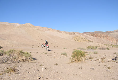
evening ride). Take 395 south thru Carson and Minden then head east on 208. You'll go thru Smith, Nv, and then come to a bridge and huge rock cliff. You can't miss it. Turn left on the hard packed dirt road here. There is RV camping (not sure about hook ups). The area to ride is relatively small but can easily handle 100 riders. The trails run everywhere and are full of banked turns, jumps and even a suicidal looking cliff that people ride up the side and back down. Not to mention one steep and very wide mountain that�s wide open. When on the top looking down it�s so steep you can't see anything below you but air. Up would be a tough climb. Down looks to be insane. Judging by the tracks many have done it. Cool trails are on the right side of the highway, but at the time of writing this, the BLM has them closed and marked for rehabilitation. In their own words "you don't need to climb every hill and there is still plenty of space available to ride". The picture to the right is of Tony out in Smith Valley. It looks like sand dunes but it�s actually a real nice sand clay mix, making for perfect riding conditions. Tony has been thinking of making an entire web site devoted to just the trails out there at Hungry Valley. There's just so much for beginners to expert. He rode there all summer on his KX500 and has only recently discovered just how much more is out there. Since then he has traded in his KX500 on a new 04 CR250R because he has decided that he wants to race next season. Really looking forward to it. Tony |
|
Fernley, Dayton, Fallon:
The Fernley track of course. Be careful when it's dry. Some spots can get like concrete.
Dayton:
Go out of Carson towards the town of Dayton. Go through Dayton until you pass Smith's food store, which you can't miss, and go past Smith's about 3 miles and look to your left side you cant miss it. Usually there are people there. There are big step ups, huge whoops and near it is a jump we call the factory double which is about 70 ft. but it has a hard case to it. I broke my collar bone on it. There are huge berms and cliff jumps. It is all here. Half of the stuff there we are scared to do.
Truckee/Sierras:
South Tahoe:
Take Hwy 50 west. Go straight at the "Y" past car dealerships and the city yard. Look for Forest Service gate on the left. Sign will say Twin Peaks OHV. The tracks open from late Spring to early Fall depending on snow. The track is mostly sand with some hard spots, but it's great training for cardio at an elevation of 6200 ft. The sign at the gate says "spark arresters required" and they mean it. The green police patrol daily. Please respect all closed areas, as we are lucky to still have an area to ride legally in the basin. There are talks of installing a water system and re-designing the track in the summer of 2001. Oh yeah! the track closes at 7:00 pm sharp due to noise complaints. Yes it's a lot of rules but it's motocross in South Tahoe.
Prosser Pits in Truckee
To get there you take 80 west from Reno until the first Truckee exit (hi-way 89) and head North for a few miles until you get to Prosser Dam Road and turn East and follow the signs to Prosser Burrow Pits OHV area. It is on Forest Service land so make sure to have a spark arrestor on. They do check. There are some good table tops and a few doubles. Bring you shoulder pads because it can get hard packed. But hey, it's a track in the mountains.
Hangtown
Directions
FROM CARSON CITY
Take Highway 50 West towards Sacramento. Approximately 5 miles past Cameron Park take the Scott Rd exit, go south to Whiterock Rd., turn right and proceed to spectator gate.
FROM RENO AND POINTS NORTHEAST
Take Highway 80 West towards Sacramento. Approximately 10 miles past Auburn before reaching Sacramento, take Sierra College Blvd. off ramp. Turn left back across the freeway and continue south all the way to Highway 50. The name will change from Sierra College Blvd. to Hazel Ave., but just continue on this same road. When you reach Highway 50, take Highway 50 East (towards Lake Tahoe). Prairie City Road (exit #25) off ramp is up two exits. Continue south on Prairie City road and follow the directions above.
Prairie City MX Park
Please CALL before leaving for any events (209)656-9682 Amp Racing
New Practice Hours at Prairie City. Monday and Wednesdays are from 4:00pm until 8:00pm (the times will gradually move back as daylight permits). Saturday and Sundays are still 9am until 3pm. The fee is $15 per rider and $1 per spectator.
Sacramento OHV Park
Operating Hours Open: Thursday - Tuesday
Closed: Wednesday
DATE
OPENS
CLOSES
May 1 - August 31
8:00 AM
8:00 PM
September 1 - September 30
8:00 AM
7:00 PM
October 1 - Last Saturday in Oct.
8:00 AM
6:00 PM
Last Sunday in October - Feb. 28
8:00 AM
5:00 PM
March 1 - March 31
8:00 AM
6:00 PM
April 1 - April 30
8:00 AM
7:00 PM
OHV Noise Regulations Noise and Red Sticker Information Packet